> ## Documentation Index
> Fetch the complete documentation index at: https://help.voxdash.com/llms.txt
> Use this file to discover all available pages before exploring further.
# Map Region Names — Import & Export
> Export a map's regions and bulk-add alternate names by re-importing the edited file.
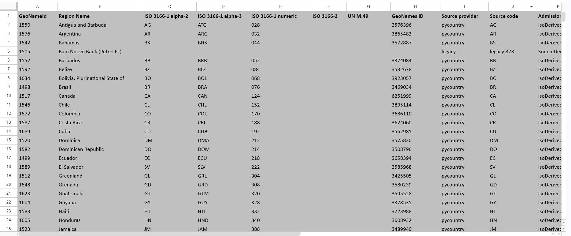
Export the regions of a map, add alternate names in Excel, then re-import to attach
them in bulk. This helps a map match more spellings and local names. Find it on the
**Maps** screen (Data Provider → Maps).
maps\_geonames\_sample.xlsx
## Export
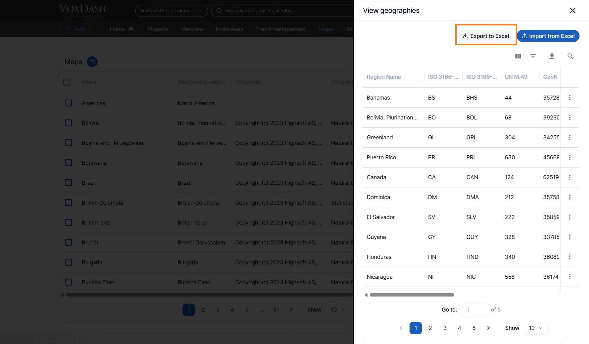
Go to **Maps** and open the map you want to enrich.
Click **Export**. The file lists every region with any names it already has.
 ## Import (add alternate names)
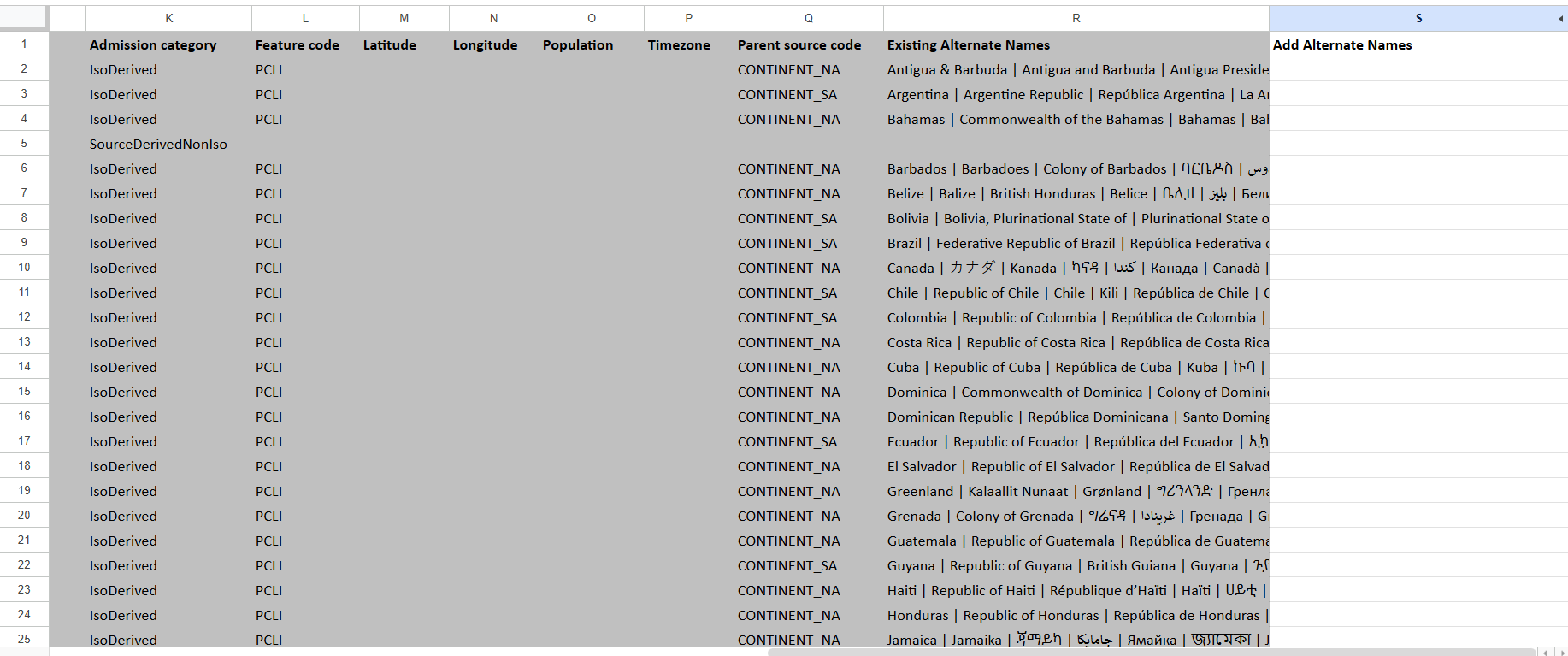
In the **Add Alternate Names** column, type the new names. Separate multiple names
with a pipe `|`, a semicolon `;`, or a new line.
Do **not** change **GeoNameId** — it identifies the region.
Click **Import** and choose your file. A summary reports how many regions were
updated and lists any skipped rows.
## Columns
| Column | Required | Description | Example |
| ------------------------ | -------- | ------------------------------------------------------------------------------------- | ----------------------------- |
| GeoNameId | Yes | Identifies the region. Do not change. | `2643743` |
| Region Name | Yes | The region’s name (for your reference). | `London` |
| Existing Alternate Names | Yes | Names already attached (export shows these). | `Greater London` |
| ISO 3166-1 alpha-2 | Yes | Two-letter country code based on ISO 3166-1 standard. | `GB` |
| ISO 3166-1 alpha-3 | Yes | Three-letter country code based on ISO 3166-1 standard. | `GBR` |
| ISO 3166-1 numeric | Yes | Numeric country code based on ISO 3166-1 standard. | `826` |
| ISO 3166-2 | Yes | Regional subdivision code based on ISO 3166-2 standard. | `GB-LND` |
| UN M.49 | Yes | United Nations geographic region numeric code. | `826` |
| GeoNames ID | Yes | Unique identifier from the GeoNames geographic database. | `2643743` |
| Source Provider | Yes | Name of the external provider supplying the geographic data. | `GeoNames` |
| Source Code | Yes | Internal or provider-specific code identifying the region. | `GB-LON` |
| Admission Category | Yes | Classification level of the geographic entity (country, state, city, district, etc.). | `City` |
| Feature Code | Yes | Geographic feature classification code. | `PPLC` |
| Latitude | Yes | Geographic latitude coordinate in decimal degrees. | `51.5074` |
| Longitude | Yes | Geographic longitude coordinate in decimal degrees. | `-0.1278` |
| Population | Yes | Estimated population count for the region. | `8982000` |
| Timezone | Yes | Standard timezone associated with the region. | `Europe/London` |
| Parent Source Code | Yes | Source code of the parent geographic entity in the hierarchy. | `GB` |
| Existing Alternate Names | Yes | Names already attached to this region from previous imports or system records. | `Greater London, Londinium` |
| Add Alternate Names | Yes | Additional alternative names to append, separated by `\|`, `;`, or new line. | `London UK \| City of London` |
## Import (add alternate names)
In the **Add Alternate Names** column, type the new names. Separate multiple names
with a pipe `|`, a semicolon `;`, or a new line.
Do **not** change **GeoNameId** — it identifies the region.
Click **Import** and choose your file. A summary reports how many regions were
updated and lists any skipped rows.
## Columns
| Column | Required | Description | Example |
| ------------------------ | -------- | ------------------------------------------------------------------------------------- | ----------------------------- |
| GeoNameId | Yes | Identifies the region. Do not change. | `2643743` |
| Region Name | Yes | The region’s name (for your reference). | `London` |
| Existing Alternate Names | Yes | Names already attached (export shows these). | `Greater London` |
| ISO 3166-1 alpha-2 | Yes | Two-letter country code based on ISO 3166-1 standard. | `GB` |
| ISO 3166-1 alpha-3 | Yes | Three-letter country code based on ISO 3166-1 standard. | `GBR` |
| ISO 3166-1 numeric | Yes | Numeric country code based on ISO 3166-1 standard. | `826` |
| ISO 3166-2 | Yes | Regional subdivision code based on ISO 3166-2 standard. | `GB-LND` |
| UN M.49 | Yes | United Nations geographic region numeric code. | `826` |
| GeoNames ID | Yes | Unique identifier from the GeoNames geographic database. | `2643743` |
| Source Provider | Yes | Name of the external provider supplying the geographic data. | `GeoNames` |
| Source Code | Yes | Internal or provider-specific code identifying the region. | `GB-LON` |
| Admission Category | Yes | Classification level of the geographic entity (country, state, city, district, etc.). | `City` |
| Feature Code | Yes | Geographic feature classification code. | `PPLC` |
| Latitude | Yes | Geographic latitude coordinate in decimal degrees. | `51.5074` |
| Longitude | Yes | Geographic longitude coordinate in decimal degrees. | `-0.1278` |
| Population | Yes | Estimated population count for the region. | `8982000` |
| Timezone | Yes | Standard timezone associated with the region. | `Europe/London` |
| Parent Source Code | Yes | Source code of the parent geographic entity in the hierarchy. | `GB` |
| Existing Alternate Names | Yes | Names already attached to this region from previous imports or system records. | `Greater London, Londinium` |
| Add Alternate Names | Yes | Additional alternative names to append, separated by `\|`, `;`, or new line. | `London UK \| City of London` |
 ## Limits & rules
| Rule | Value |
| -------------------------------- | --------------------------------------------------------------------------- |
| File type | `.xlsx` only (contents verified) |
| Maximum size | 10 MB |
| Maximum rows | 50,000 |
| New names per row | 50 |
| Total alternate names per region | 200 |
| Length of one alternate name | 255 characters |
| Access | Public map: any signed-in user. Private map: Catalog-level access or above. |
Only rows whose **GeoNameId** belongs to this map are applied; others are reported as
skipped. Duplicate or already-present names are ignored.
## Limits & rules
| Rule | Value |
| -------------------------------- | --------------------------------------------------------------------------- |
| File type | `.xlsx` only (contents verified) |
| Maximum size | 10 MB |
| Maximum rows | 50,000 |
| New names per row | 50 |
| Total alternate names per region | 200 |
| Length of one alternate name | 255 characters |
| Access | Public map: any signed-in user. Private map: Catalog-level access or above. |
Only rows whose **GeoNameId** belongs to this map are applied; others are reported as
skipped. Duplicate or already-present names are ignored.